history and maps

Cottingham - name, size and location

Ancient and Roman Britain

Angles, Saxons and Vikings

Anglo Saxon Chronicle

Domesday Book

The Hundreds

Rockingham Forest

Rockingham Castle

landowners & copyholders

The Church, tithes & glebe

Kelly's Directories


Ancient and Roman Britain


Coritanidraworiginal2.gif (48358 bytes)


Ancient British tribes and

major Roman roads

Ancient Britain


Prior to Roman occupation of Britain, England was divided into 22 tribal areas, each with their own king, or chief. At this time, Cottingham lay within lands occupied by the Coritani (or Corieltauvi) tribe, whose lands stretched between the Rivers Welland and Humber, fringed on the west by the southern Pennines. Coins of the Coritani tribe have been found at Corby, Gretton and Kettering.

There was an iron age settlement on the hilltop where Rockingham Castle now stands, and major iron age centres at Leicester and Sleaford. Iron age settlements consisted of dwellings made from timber, wattle and daub. It wasn't until the arrival of the invading Roman army in AD 43 that stone buildings were erected.

Roman Roads.gif (5990 bytes)


Map courtesy of 

www.romans-in-britain.org.uk


The 'Via Devana' through Cottingham


Back to top of page

Roman Britain


In AD 43, the Roman Emperor Claudius invaded ‘Britannia’. Between AD 70 and 80, Coritani became a ‘civitas’ meaning that the tribe was allowed to govern itself. The administrative centre for this local government area was in Leicester, then known as 'Ratrae Coritanorium'.


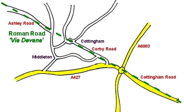
In Cottingham, the Roman Road 'Via Devana' from Leicester to Huntingdon runs along the route of Corby Road, School Lane, Cottingham Road and Ashley Road. Part of this road was later known as Gartree Way


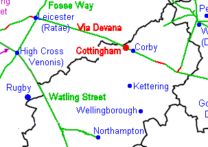
The maps opposite show the route of the Via Devana, which connected two major Roman Roads - Fosse Way and Ermine Street. Fosse Way ran from the South West, through the Midlands and up to Lincoln. Ermine Street ran down the east coast, linking London to the Scottish border. The major Roman roads criss-crossing the country are shown on the map above.


Remains of a Roman building were discovered in Bury Close when the new bungalows were built.