Anglo-Saxon
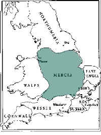
Britain - The Heptarchy
Map by
Dafydd Gibbon
|
Between the 4th and 7th Centuries, Angles and Saxons
from north Germany settled in Britain, hence the collective name ‘Anglo-Saxon’.
At this time, England was roughly divided into seven kingdoms known as the 'Heptarchy'.
Cottingham lay within the kingdom of Mercia
The name ‘Mercians’ means ‘the
borderers’, thought to derive from Mercia’s position bordering several other
provinces.
The first recorded king of Mercia was Cearl, but it was Penda
(c626-655) who established Mercia as major Anglo-Saxon kingdom. Over the next
200 years, Mercia was ruled by a succession of Anglo-Saxon kings, during which
time, many of the surrounding provinces came under Mercian control.
Mercia fell to Viking invaders in 874,
and many Northamptonshire place names have viking origins. For example, Corby
translates as 'Kori's village', with Kori having been a Viking chief, and 'by'
being a common name ending in Scandinavia, especially Denmark.
By 954, all of England south
of the Humber was precariously united under a single Anglo-Saxon King, Athelstan
(924-39), grandson of King Alfred the Great, who initiated
the Anglo Saxon Chronicle
|